Baseline characterization helps to understand the initial livelihood condition of the people in the watershed before and after the intervention of the project to measure the amount of change attained by the project. The objective of the study was to characterize baseline information on the existing biophysical resource used as benchmark for planning and impact monitoring and to identify and major constraints and potential in the watershed. The watershed was selected depending on agro-ecological representation, prevalence of resource management and land degradation problems and accessibility for intensive follow-up. Based on the preliminary outlet identified during the watershed selection process, the watershed boundary was delineated using GPS data and the map of watershed was geo-referenced and digitized for its contour, roads, rivers, and other features. Both primary and secondary data were used for the study and primary data was collected through field observation, household survey, focus group discussion and interview of the key informants. From the total 103 household heads living in the watershed, 62 household heads were selected as a respondent for the study. The collected data was managed and analyzed using Statistical Package for Social Sciences (SPSS) and Microsoft excel 2010. The results of the study showed that about 29.4% of the watershed slope was characterized by flat lands, 45.7% moderate slope and 24.9% steep lands. As well as soil fertility status of cultivated land in the watershed were 33.9% low, 55.9% moderate and 10.2% high. The results of the study showed that the major constraints identified by sampled household heads were decline of soil fertility, soil erosion, climate change, land shortage, and deforestation were significantly contributed to the low crop yield in the watershed. About 27.4% of the sampled households had encountered decline of soil fertility problems, 25.8% of sample farmers encountered soil erosion problem, and 22.6% of sample farmers encountered climate change problem in the watershed. From the identified major constraints, the highest priorities were given for decline of soil fertility, soil erosion problem, shortage of feed and fodder, and decline of crop productivity respectively. In the watershed, immediate short-term actions should be taken particularly participatory integrated watershed management were recommended.
| Published in | Agriculture, Forestry and Fisheries (Volume 13, Issue 4) |
| DOI | 10.11648/j.aff.20241304.11 |
| Page(s) | 94-105 |
| Creative Commons |
This is an Open Access article, distributed under the terms of the Creative Commons Attribution 4.0 International License (http://creativecommons.org/licenses/by/4.0/), which permits unrestricted use, distribution and reproduction in any medium or format, provided the original work is properly cited. |
| Copyright |
Copyright © The Author(s), 2024. Published by Science Publishing Group |
Watershed, Characterization, Identification, Prioritization
Characters | Description | Plot of land | |
|---|---|---|---|
Frequency | Percent | ||
Slope of land | Flat | 72 | 29.4 |
Medium | 112 | 45.7 | |
Steep | 61 | 24.9 | |
Soil Fertility status | Low | 83 | 33.9 |
Moderate | 137 | 55.9 | |
High | 25 | 10.2 | |
Soil Color | Red | 132 | 53.9 |
Black | 17 | 6.9 | |
Gray | 4 | 1.6 | |
Brown | 92 | 37.6 | |
Degree of Soil Erosion | Slight | 84 | 34.3 |
Moderate | 108 | 44.1 | |
Severe | 46 | 18.8 | |
Not recognized | 7 | 2.9 | |
Type of SWC practices | Frequency | Percent | Type of SWC practices | Frequency | Percent |
|---|---|---|---|---|---|
A. Agronomic practices | B. Physical SWC practices | ||||
Mono cropping | 3 | 5 | Soil bund | 8 | 13 |
Rotation (cereals – pulse) | 42 | 68 | Stone bund | 7 | 11 |
Rotation (cereal-cereal) | 15 | 24 | Terrace | 5 | 8 |
Rotation (cereal – others) | 2 | 3 | Cut-off drain | 9 | 15 |
Home garden | 8 | 13 | Water way | 31 | 50 |
Broadcasting sowing | 62 | 100 | C. Biological SWC practices | ||
Conventional tillage practice | 44 | 71 | Using local grass | 9 | 15 |
Conservation tillage practice | 18 | 29 | Road side plantation | 6 | 10 |
0% crop residue left | 54 | 87 | Farm boundary plantation | 9 | 15 |
50% crop residue left | 8 | 13 | Buffer stripe | 1 | 2 |
D. Gully Control | Area closure (ha) | 5 | 8 | ||
Stone Check dam | 5 | 8 | |||
Brush wood | 1 | 2 | |||
Others | 1 | 2 | |||
Land use/ land cover | Area coverage in 2022 | |
|---|---|---|
In (ha) | In (%) | |
Forest land | 10.48 | 1.6 |
Cultivated land | 490.87 | 73.2 |
Grazing land | 111.26 | 16.6 |
Scattered tree on the farm | 48.62 | 7.2 |
Settlements | 9.43 | 1.4 |
Total land | 670.67 | 100 |
Slope Class | Area (ha) | Area (%) |
|---|---|---|
Flat (0-3%) | 23.9 | 3.6 |
Gently Sloping (3-8%) | 140.8 | 21.0 |
Moderately Steep (8-15%) | 202.8 | 30.2 |
Sloping (15-30%) | 242.9 | 36.2 |
Steep (>30%) | 60.27 | 9.0 |
Total | 670.67 | 100 |
Land and soil related constraints | Frequency | Percent |
|---|---|---|
Decline of Soil Fertility | 17 | 27.4 |
Soil Erosion | 16 | 25.8 |
Climate Change | 14 | 22.6 |
Land Shortage | 10 | 16.1 |
Deforestation | 5 | 8.1 |
Total | 62 | 100.0 |
Decline of soil fertility | Soil erosion | Climate change | Shortage of agricultural inputs | Decline of crop productivity | Crop disease | |
|---|---|---|---|---|---|---|
Decline of soil fertility | 0 | 1 | 1 | 1 | 1 | |
Soil erosion | 1 | 1 | 1 | 1 | 1 | |
Climate change | 0 | 0 | 0 | 0 | 1 | |
Shortage of agricultural inputs | 0 | 0 | 1 | 1 | 1 | |
Decline of crop productivity | 1 | 0 | 1 | 0 | 1 | |
Crop disease | 0 | 0 | 0 | 0 | 0 | |
Shortage of feed and fodder | 0 | 1 | 1 | 1 | 1 | 1 |
Lack of employment opportunity | 0 | 0 | 1 | 0 | 0 | 1 |
Inflation | 0 | 0 | 1 | 1 | 0 | 0 |
Lack of drinking water | 0 | 0 | 0 | 0 | 0 | 0 |
Shortage of feed and fodder | Lack of employment opportunity | Inflation | Lack of drinking water | Score | priority | |
|---|---|---|---|---|---|---|
Decline of soil fertility | 1 | 1 | 1 | 1 | 8 | 1 |
Soil erosion | 0 | 1 | 1 | 1 | 8 | 1 |
Climate change | 0 | 0 | 0 | 1 | 2 | 5 |
Shortage of agricultural inputs | 0 | 1 | 0 | 1 | 5 | 4 |
Decline of crop productivity | 0 | 1 | 1 | 1 | 6 | 3 |
Crop disease | 0 | 0 | 1 | 1 | 2 | 5 |
Shortage of feed and fodder | 0 | 1 | 1 | 7 | 2 | |
Lack of employment opportunity | 1 | 1 | 1 | 5 | 4 | |
Inflation | 0 | 0 | 0 | 2 | 5 | |
Lack of drinking water | 0 | 0 | 1 | 1 | 6 |
Potentials | Frequency | Percent |
|---|---|---|
A. Natural resource potentials | ||
Sand and coble stone | 27 | 43.5 |
Permanent river | 13 | 21.0 |
Forest | 12 | 19.4 |
Suitable agro-ecology | 10 | 16.1 |
Total | 62 | 100.0 |
°C | Degree Centigrade |
GDP | Gross Domestic Product |
GPS | Global Positioning System |
ha | Hectare |
Km | Kilometers |
km2 | Square Kilometers |
mm | Millimeters |
SPSS | Statistical Package for Social Sciences |
| [1] | Vlek P, Bao Le Q, Tamene L (2008) Land decline in land-rich Africa: a creeping disaster in the making, pp 12–54. |
| [2] | Desta, L.; Carucci, V.; Wendem-Ageňehu, A.; Abebe, Y. (Eds). 2005. Community based participatory watershed development: A guideline. Addis Ababa, Ethiopia: Ministry of Agriculture and Rural Development (MoARD). |
| [3] | Pimentel, D. (2006). Soil Erosion: A Food and Environmental Threat; Journal of Environment, Development and Sustainability, 8: 119–137. |
| [4] | Mekonen K, Tesfahunegn GB (2011) Impact assessment of soil and water conservation measures at Medego watershed in Tigray, northern Ethiopia. Maejo Int J Sci Technol 5(3): 312–330. |
| [5] | Demelash M, Stahr K (2010) Assessment of integrated soil and water conservation measures on key soil properties in South Gonder, North-Western Highlands of Ethiopia. J Soil Sci Environ Management 1(7): 164–176. |
| [6] | Hurni H, Abate S, Bantider A, Debele B, Ludi E, Portner B, Yitaferu B, Zeleke G (2010) Land degradation and sustainable land management in the highlands of Ethiopia. In: Hurni H, Wiesmann U (eds) with an international group of co-editors. Global change and sustainable development: a synthesis of Regional experiences from research partnerships. Perspectives of the Swiss national centre of competence in research (NCCR) North South, University of Bern, Vol. 5. Geographical Bernensia. Bern, Switzerland. |
| [7] | Atnafe AD, Ahmed HM, Adane DM (2015) Determinants of adopting techniques of soil and water conservation in Goromti Watershed, Western Ethiopia. J Soil Science Environmental Management 6(6): 168–177. |
| [8] | Bewket W, Teferi, E. (2009). Assessment of soil erosion hazard and prioritization for treatment at the watershed level: case study in the Chemoga watershed, Blue Nile basin, Ethiopia. Land Degradation Dev, 20, 609–622. |
| [9] | Lemenih, M. 2004. Effects of Land use Change on Soil Quality and Native Flora Degradation and Restoration in the Highlands of Ethiopia. Implication for Sustainable Land Management. Swedish University of Agricultural Science. Uppsala, Sweden. |
| [10] | Gebremedhin Yihdego (2004). Community Participation and Sustainable Soil and Water Conservation Management. The Case of Zala-Daget Project: Dogu’a Tembien WoredaTigray Highlands. Unpublished Master Thesis, Addis Ababa University, School of Graduate Studies, Addis Ababa. |
| [11] | Gebregziabher, G., Abera, D. A., Gebresamuel, G., Giordano, M. & Langan, S. (2016). An assessment of integrated watershed management in Ethiopia (Vol. 170). International Water Management Institute (IWMI). |
| [12] | Bonsa Fentale Jilo, Gemeda Terfassa Fida, Desta Negayo Komicho. (2020) Socio-economic and Biophysical Resources Characterization of ‘Warja’ Watershed in Adami Tulu Jido Kombolcha District, East Shewa Zone, Oromia, Ethiopia. |
| [13] | Bekele A (2006). Participatory watershed management: Lessons from RELMA‟s work with f armers in eastern Africa. ICRAF Working, P. 22. |
| [14] | Schmidt, E. and Tadesse, F (2012). Household and Plot Level Impact of Sustainable Land and Watershed Management (SLWM) Practices in the Blue Nile. Ethiopia Strategy Support Program II (ESSP II) ESSP II Working Paper 42, Ethiopia, August. |
| [15] | Tesfaye A, Githiri M, Derera J, Debele T (2011). Subsistence f armers‟ experience and perception about the soil, and fertilizer use in Western Ethiopia. Ethiop J ApplSciTechnol, 2: 61-74. |
| [16] | Geta E, Bogale A, Kassa B, Elias E, (2013). Determinants of Farmers‟ Decision on Soil Fertility Management Options for Maize Production in Southern Ethiopia. Am J Experimental Agric, 3: 226-239. |
| [17] | Vancampenhout K, Nyssen J, Gebremichael D, Deckers J, Poesen J, Haile M (2006). Stone bunds for soil conservation in the northern Ethiopian highlands: impacts on soil fertility and crop yield. Soil Tillage Res, 90: 1-15. |
| [18] | Tesfaye A, Negatu W, Brouwer R, van der Zaag P (2014). Understanding soil conservation decision of farmers in the gedeb watershed, Ethiopia. Land DegradDev 25: 71-79. |
| [19] | Betteridge, K., Mackay, A. D., Shepherd T. G., Barker D. J., Budding P. J., Devantier B. P., & Costall D. A. (1999). Effect of cattle and sheep treading on surface configuration of a sedimentary hill soil. Soil Research, 37(4), pp. 743-760. |
| [20] | Bewket, W. and G. Sterk, (2003). Assessment of soil erosion in cultivated fields using a survey methodology for rills in the Chemoga watershed, Ethiopia, Agr. Ecosyst. Environ., 97: 81-93. |
| [21] | Muia VK, Ndunda E (2013). Evaluating the impact of direct anthropogenic activities on land degradation in arid and semi-arid regions in Kenya. |
| [22] | Ifejika SC, Kiteme B, Wisemann U (2008). Droughts and famine, the underlying factors and causal links among agro-pastoral households in semi-arid Makueni District, Kenya. Glob Environ Chang 18: 220-233. |
| [23] | FAO, (2010c). Global Forest Resources Assessment 2010 key findings, Rome. |
APA Style
Bedada, E., Mengistu, B., Muluna, M., Tolosa, M., Jifara, M., et al. (2024). Biophysical Resource Characterization, Identification and Prioritization of Major Constraints and Potentials of Gara Ebanu Community Watershed in Sululta District, Ethiopia. Agriculture, Forestry and Fisheries, 13(4), 94-105. https://doi.org/10.11648/j.aff.20241304.11
ACS Style
Bedada, E.; Mengistu, B.; Muluna, M.; Tolosa, M.; Jifara, M., et al. Biophysical Resource Characterization, Identification and Prioritization of Major Constraints and Potentials of Gara Ebanu Community Watershed in Sululta District, Ethiopia. Agric. For. Fish. 2024, 13(4), 94-105. doi: 10.11648/j.aff.20241304.11
AMA Style
Bedada E, Mengistu B, Muluna M, Tolosa M, Jifara M, et al. Biophysical Resource Characterization, Identification and Prioritization of Major Constraints and Potentials of Gara Ebanu Community Watershed in Sululta District, Ethiopia. Agric For Fish. 2024;13(4):94-105. doi: 10.11648/j.aff.20241304.11
@article{10.11648/j.aff.20241304.11,
  author = {Endale Bedada and Bikila Mengistu and Meseret Muluna and Meron Tolosa and Mengistu Jifara and Alemayehu Biri and Firaol Legesse and Ajema Lemma and Bedo Hora and Lemma Teklu and Woubalem Abera},
  title = {Biophysical Resource Characterization, Identification and Prioritization of Major Constraints and Potentials of Gara Ebanu Community Watershed in Sululta District, Ethiopia
},
  journal = {Agriculture, Forestry and Fisheries},
  volume = {13},
  number = {4},
  pages = {94-105},
  doi = {10.11648/j.aff.20241304.11},
  url = {https://doi.org/10.11648/j.aff.20241304.11},
  eprint = {https://article.sciencepublishinggroup.com/pdf/10.11648.j.aff.20241304.11},
  abstract = {Baseline characterization helps to understand the initial livelihood condition of the people in the watershed before and after the intervention of the project to measure the amount of change attained by the project. The objective of the study was to characterize baseline information on the existing biophysical resource used as benchmark for planning and impact monitoring and to identify and major constraints and potential in the watershed. The watershed was selected depending on agro-ecological representation, prevalence of resource management and land degradation problems and accessibility for intensive follow-up. Based on the preliminary outlet identified during the watershed selection process, the watershed boundary was delineated using GPS data and the map of watershed was geo-referenced and digitized for its contour, roads, rivers, and other features. Both primary and secondary data were used for the study and primary data was collected through field observation, household survey, focus group discussion and interview of the key informants. From the total 103 household heads living in the watershed, 62 household heads were selected as a respondent for the study. The collected data was managed and analyzed using Statistical Package for Social Sciences (SPSS) and Microsoft excel 2010. The results of the study showed that about 29.4% of the watershed slope was characterized by flat lands, 45.7% moderate slope and 24.9% steep lands. As well as soil fertility status of cultivated land in the watershed were 33.9% low, 55.9% moderate and 10.2% high. The results of the study showed that the major constraints identified by sampled household heads were decline of soil fertility, soil erosion, climate change, land shortage, and deforestation were significantly contributed to the low crop yield in the watershed. About 27.4% of the sampled households had encountered decline of soil fertility problems, 25.8% of sample farmers encountered soil erosion problem, and 22.6% of sample farmers encountered climate change problem in the watershed. From the identified major constraints, the highest priorities were given for decline of soil fertility, soil erosion problem, shortage of feed and fodder, and decline of crop productivity respectively. In the watershed, immediate short-term actions should be taken particularly participatory integrated watershed management were recommended.
},
 year = {2024}
}
TY  - JOUR
T1  - Biophysical Resource Characterization, Identification and Prioritization of Major Constraints and Potentials of Gara Ebanu Community Watershed in Sululta District, Ethiopia

AU  - Endale Bedada
AU  - Bikila Mengistu
AU  - Meseret Muluna
AU  - Meron Tolosa
AU  - Mengistu Jifara
AU  - Alemayehu Biri
AU  - Firaol Legesse
AU  - Ajema Lemma
AU  - Bedo Hora
AU  - Lemma Teklu
AU  - Woubalem Abera
Y1  - 2024/07/15
PY  - 2024
N1  - https://doi.org/10.11648/j.aff.20241304.11
DO  - 10.11648/j.aff.20241304.11
T2  - Agriculture, Forestry and Fisheries
JF  - Agriculture, Forestry and Fisheries
JO  - Agriculture, Forestry and Fisheries
SP  - 94
EP  - 105
PB  - Science Publishing Group
SN  - 2328-5648
UR  - https://doi.org/10.11648/j.aff.20241304.11
AB  - Baseline characterization helps to understand the initial livelihood condition of the people in the watershed before and after the intervention of the project to measure the amount of change attained by the project. The objective of the study was to characterize baseline information on the existing biophysical resource used as benchmark for planning and impact monitoring and to identify and major constraints and potential in the watershed. The watershed was selected depending on agro-ecological representation, prevalence of resource management and land degradation problems and accessibility for intensive follow-up. Based on the preliminary outlet identified during the watershed selection process, the watershed boundary was delineated using GPS data and the map of watershed was geo-referenced and digitized for its contour, roads, rivers, and other features. Both primary and secondary data were used for the study and primary data was collected through field observation, household survey, focus group discussion and interview of the key informants. From the total 103 household heads living in the watershed, 62 household heads were selected as a respondent for the study. The collected data was managed and analyzed using Statistical Package for Social Sciences (SPSS) and Microsoft excel 2010. The results of the study showed that about 29.4% of the watershed slope was characterized by flat lands, 45.7% moderate slope and 24.9% steep lands. As well as soil fertility status of cultivated land in the watershed were 33.9% low, 55.9% moderate and 10.2% high. The results of the study showed that the major constraints identified by sampled household heads were decline of soil fertility, soil erosion, climate change, land shortage, and deforestation were significantly contributed to the low crop yield in the watershed. About 27.4% of the sampled households had encountered decline of soil fertility problems, 25.8% of sample farmers encountered soil erosion problem, and 22.6% of sample farmers encountered climate change problem in the watershed. From the identified major constraints, the highest priorities were given for decline of soil fertility, soil erosion problem, shortage of feed and fodder, and decline of crop productivity respectively. In the watershed, immediate short-term actions should be taken particularly participatory integrated watershed management were recommended.

VL  - 13
IS  - 4
ER  -
Oromia Agricultural Research Institute, Fitche Agricultural Research Center, Fitche, Ethiopia
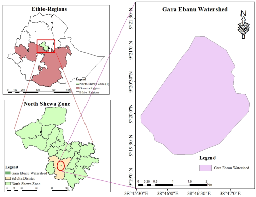
Figure 1. Map of Gara Ebanu watershed.
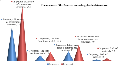
Figure 2. The reasons of farmers not using structures in their farm lands in the watershed.
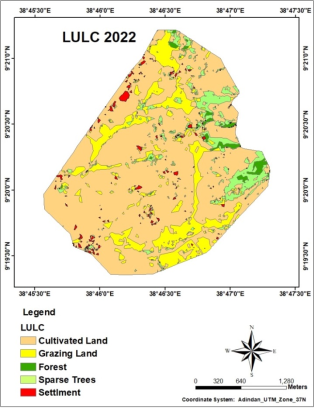
Figure 3. Land use land cover map of Gara Ebanu watershed.
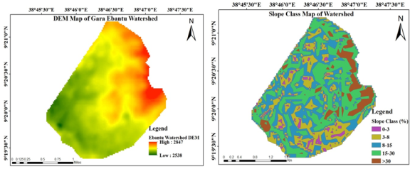
Figure 4. DEM and slope class map of Gara Ebanu watershed.
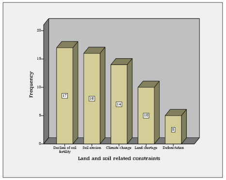
Figure 5. Graph of major constraints related to land and soil in the watershed.